What is going on here?

jpell

Cadet
Joined
Oct 30, 2012
Messages
10
Does anybody understand why my display is blank for large sections of my local waters? Contour lines just disappear.
 

Attachments

  • photo322697.jpg
    photo322697.jpg
    28.9 KB · Views: 0

dingbat

Supreme Mariner
Joined
Nov 20, 2001
Messages
16,622
Nice start line.......no survey data or that map sector isn’t included in your map set
 

StingrayMike

Petty Officer 1st Class
Joined
Aug 17, 2014
Messages
355
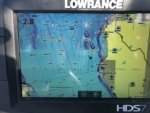
It looks like that data is not included on your map. It will continue on a different map.
You might have to get the other chart to see the rest.
Go to Lowrance website and see the coverage of your chart.

I have seen other manufacturers include up to a certain point, then cut if off like that. if you want the rest of the data, you need to buy the rest the chart
 

jhebert

Ensign
Joined
Jul 24, 2005
Messages
903
In some situations the chart display information changes with the scale used in the presentation ("zoom").


ASIDE: Usually a Lowrance chart plotter provides for making and exporting screen capture image files. Using a screen capture image file is a much better way to illustrate the screen appearance than a photograph.
 
Last edited:
Top