Fishfinder help...

jhande

Chief Petty Officer
Joined
Jun 26, 2010
Messages
442
Since I've only fished from a canoe and I'm kind of nervous of deep water, I've only fished 30' or less. Most of my fishing has really been in the shallows in weed beds or rocky shores.

Maybe, hopefully I might feel more comfortable being in a larger boat to fish (troll) for trout in deeper waters. Definitely no where near 400'. :eek:
 

PC on the Bayou

Petty Officer 1st Class
Joined
Apr 27, 2020
Messages
234
Generally speaking, side imaging gives you a field of view of the bottom 2x the depth of the water.

If your in 6’ of water, your field of view of the bottom is 12’. On a boat with 8’ beam, your looking at 2’ off each side.

The bigger issue is viewing. Compressing 12’ of images on a 5” diagonal screen don’t cut it.

I think that this is incorrect. With Down Imaging, it is the 2x depth for width of beam. For Side View, the beam goes from vertical to nearly 90 degrees to each side. The water column is shown in the middle of the screen with deeper water showing a wider column area in the middle. The bottom is shown out to whatever distance you have it set for to either side of the water column.

side view.jpg

In this picture, the 13.5 feet directly below the boat is shown as the dark area down the middle. The overall image shows about 80 feet to either side. The amber areas to either side of the water column show from directly under the boat (the border between the dark and amber) out to the specified distance in either direction. The right side shows the bank line to the right of the boat as dark area.

To the OP's original question, I find that the side view works well in shallow water. You just have to learn how to interpret it.

I do, agree, however that if you go with Side View, you'll want as big a screen as you can afford. I have a 5 inch model Humminbird Helix 5 SI/GPS which limits the ability to interpret if I have it set for too wide an area.
 

PC on the Bayou

Petty Officer 1st Class
Joined
Apr 27, 2020
Messages
234
Since I've only fished from a canoe and I'm kind of nervous of deep water, I've only fished 30' or less. Most of my fishing has really been in the shallows in weed beds or rocky shores.

Maybe, hopefully I might feel more comfortable being in a larger boat to fish (troll) for trout in deeper waters. Definitely no where near 400'. :eek:

I think of it this way. Once the water is over my head in depth, it really doesn't matter how deep it is. I still would have to float / swim. LOL

One thing I do know, though, is that deeper water can produce larger waves. And it seems (maybe incorrectly) that shallow water conditions change quicker.
 

dingbat

Supreme Mariner
Joined
Nov 20, 2001
Messages
16,337
I think that this is incorrect. With Down Imaging, it is the 2x depth for width of beam. For Side View, the beam goes from vertical to nearly 90 degrees to each side. The water column is shown in the middle of the screen with deeper water showing a wider column area in the middle. The bottom is shown out to whatever distance you have it set for to either side of the water column.

View attachment 336599

In this picture, the 13.5 feet directly below the boat is shown as the dark area down the middle. The overall image shows about 80 feet to either side. The amber areas to either side of the water column show from directly under the boat (the border between the dark and amber) out to the specified distance in either direction. The right side shows the bank line to the right of the boat as dark area.

To the OP's original question, I find that the side view works well in shallow water. You just have to learn how to interpret it.

I do, agree, however that if you go with Side View, you'll want as big a screen as you can afford. I have a 5 inch model Humminbird Helix 5 SI/GPS which limits the ability to interpret if I have it set for too wide an area.


For Side View, the beam goes from vertical to nearly 90 degrees to each side.
According to Garmin the beam is 2 degrees wide by 50-53 degrees (25-26.5 degrees each side) depending on the transducer in question
1617130827022.png
1617130850504.png
 

Attachments

  • 1617129904600.png
    1617129904600.png
    72.2 KB · Views: 2

PC on the Bayou

Petty Officer 1st Class
Joined
Apr 27, 2020
Messages
234
According to Garmin the beam is 2 degrees wide by 50-53 degrees (25-26.5 degrees each side) depending on the transducer in question
View attachment 336605
View attachment 336606

That's interesting. I'm basing my discussion on Humminbird Side View. I know theirs goes nearly 180 degrees side to side. I can back that up with experience with my Helix Side Imaging.

I would be surprised if Garmin's didn't as well. When looking at that link, it isn't 100 percent clear to me if the chart isn't just refering to ClearVu. Here is another link to a Garmin Article that shows the beam width graphics for ClearVu and SideVu.

https://support.garmin.com/en-US/marine/faq/moH7wuZ0ySA8uVxEvxjcp8/

I'm going to definitely look into this more. I'm considering upgrading from my Helix 5 to a larger Garmin. Part of the decision is the availability of the mapping with Garmin (who acquired Navionics); so, they now include their basemaps.
 

jhande

Chief Petty Officer
Joined
Jun 26, 2010
Messages
442
Thanks PC for chiming in.
I watched a lot of YouTube videos regarding fish finders/sonar.
Once one learns how to read their screens all 3 types play well together.
In many of the videos side imaging was especially used for such things as under boat docks, shallow water along shore (just to name a few). It seemed to work well where you could not get your boat to use traditional down scanning.

I'm definitely dropping my max price point. Instead I'm just looking now at size (9"+) and features. I think I have the features narrowed down some. But now I'm wondering... The scanner will be mounted at the helm but what about at the bow where I'm fishing from? One step at a time though. If I plan ahead maybe I can afford one that networks together for future expansion?

I'm more accustomed to that type of fishing but casting into the unknown. I know fish move/migrate to different spots during the day and also seasonally (water temps) but I've always been casting into the unknown. I mean sure I find cover (fell tree's, rocky shores, etc...) but the fish aren't always there. In a few of my local ponds and lakes I don't dare take a motor boat where I took my canoe to some of the seasonal hot spots. Once I learn how to read a fish finder I'm hoping it will help cut down on hours of wasted cast where there's no fish LOL.

As far as fishing really deep water... I'll probably nut up and put my big boy panties on. :LOL:
It took me awhile but I did venture out into deep water with my canoe. Granted I didn't know how deep it really was until after the fact. :eek:
 

PC on the Bayou

Petty Officer 1st Class
Joined
Apr 27, 2020
Messages
234
Thanks PC for chiming in.

. . .

You're welcome. I try to give good information where I have either experience or some knowledge. I did a lot of reading about Down View and Side View before purchasing my unit a few years ago.

My Helix is only a 5 inch model. I bought it second hand from someone who was upgrading and after using it for a while, I can see why they chose to upgrade. The 5 inch screen is a bit small for using for side imaging; but, it was the right price point when I bought it. I couldn't spend big bucks on a large screen for occasional recreational fishing.

With regard to helm mount vs bow mount. Again because of cost, I share my head unit in both places. My power and transducer cord are long enough that I can simply move my head unit (on a RAM Mount) to a spot in the bow if I want to be able to see it when fishing from there. I, also, have a second transducer that I've occasionally mounted on the trolling motor in the front. However, having side imaging on the trolling motor is somewhat handicapped when I have to turn the motor frequently if the water isn't smooth or it is windy.

Since I see you fish from a canoe, I would offer that I've also used my Helix and spare transducer from my canoe. I built a PVC transducer mount that I can put in the rear of my canoe and use a clamp to mount the head unit. I, also, have a small (Powerwheels) battery to use to power the unit if I want it to be portable.

I'm considering an upgrade in the not-to-distant future to a Garmin unit from my Humminbird. Although I like the Humminbird, the mapping availability for it is limited in the areas I fish (south Louisiana), so, the standard mapping from Garmin would suite me fine. I am definitely going to save pennies to get a larger screen for my oldish eyes.
 

jhande

Chief Petty Officer
Joined
Jun 26, 2010
Messages
442
The 5 inch screen is a bit small for using for side imaging; but, it was the right price point when I bought it. I couldn't spend big bucks on a large screen for occasional recreational fishing.
I was trying to jump on board quickly with a fish finder. But I'm now willing to wait until I can get something bigger. I knew a 5" screen would be too small, not even sure 9" would be good.

With regard to helm mount vs bow mount. Again because of cost, I share my head unit in both places.
I was considering doing that. Wasn't sure if I had to drag cables and wires or if their's such a thing as a splitter transducer wire. Haven't investigated that yet.

Since I see you fish from a canoe, I would offer that I've also used my Helix and spare transducer from my canoe.
The canoe has been retired for years, my old back can't do it anymore. I'll be using the Glastron in my signature once I'm done re-decking it.

... the standard mapping from Garmin would suite me fine. I am definitely going to save pennies to get a larger screen for my oldish eyes.
I started looking into mapping but haven't come across any of my local lakes listed, but I'm still researching. Like you, my 61 year old eyes don't see so well anymore so the bigger the better.
 

dingbat

Supreme Mariner
Joined
Nov 20, 2001
Messages
16,337
That's interesting. I'm basing my discussion on Humminbird Side View. I know theirs goes nearly 180 degrees side to side. I can back that up with experience with my Helix Side Imaging.

I would be surprised if Garmin's didn't as well. When looking at that link, it isn't 100 percent clear to me if the chart isn't just refering to ClearVu. Here is another link to a Garmin Article that shows the beam width graphics for ClearVu and SideVu.

https://support.garmin.com/en-US/marine/faq/moH7wuZ0ySA8uVxEvxjcp8/

I'm going to definitely look into this more. I'm considering upgrading from my Helix 5 to a larger Garmin. Part of the decision is the availability of the mapping with Garmin (who acquired Navionics); so, they now include their basemaps.
Humminbird plays games with their performance specifications.

My biggest gripe is the use of non-industry standard units of measure, purposely making it hard to make a side by side comparison of performance.

Case in Point:
1. Output Power measured in Peak Power instead of RMS watts.
2. Beam coverage rated -10 dB instead of -3 dB.

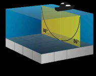
Taken from Humminbird manual
Side Imaging
Operating Frequency .....................................455 kHz, 800 kHz,
Area of Coverage ...... 455 kHz: 86° @ -10 dB
800 kHz: 86° @ -10 dB

From my GT51-M-TM CHIRP transducer specification
Side Imaging
Operating Frequency ..........260 kHz (245-275 kHz), 455 kHz (445-465 kHz)
Area of Coverage ...... 245-275 kHz, 51° @ -3 dB
445-465 kHz, 29° @ -3 dB

The first thing I notice about both specifications is that 2 x "coverage" doesn't equal 180°.

The second thing I notice is the HB beams are rated at -10dB.....
Can't say with certainty w/o Transmit Radiation Pattern data for this particular transducer, but generally speaking, the area of coverage at -10dB is roughly twice that of -3dB, making the HB roughly 43° at -3dB

The other thing I notice is that the beam width on the HB stayed the same at both frequencies. Beam width decreases as frequency increases.

What does all this tell us......neither can "array" 180° unless they use a third transducer to build a "mosaic of the area.
 

PC on the Bayou

Petty Officer 1st Class
Joined
Apr 27, 2020
Messages
234
What does all this tell us......neither can "array" 180° unless they use a third transducer to build a "mosaic of the area.

You are certainly more technically savvy on the specifics of frequencies, power, and angles than I am; so, I certainly can't contradict anything you said. What I do know is that on my Helix, the readings on-screen certainly appear to cover near 180 degrees (172 degrees ??). I can definitely see more width than just double the depth. When I pass a dock, piling, other objects, or shoreline that I can verify are off to the side of the boat, I can definitely see it on the screen images. Don't know how they do their magic, but they do. LOL.

I started looking into mapping but haven't come across any of my local lakes listed, but I'm still researching. Like you, my 61 year old eyes don't see so well anymore so the bigger the better.

That's one of the problems I have as well. None of the detailed lake mapping (i.e., contour) cards cover Lake Pontchartrain and the surrounding area. All I can do is use the coastal mapping to get a pretty good idea. What I do use the mapping on my Helix for is to locate known reefs, well heads, shell beds, etc. that others have posted for our area and I have setup as waypoints.
 
Top