Re: WTH!!, its SNOWING
Here it comes WIMUSKY. At least in Saint Paul, MN. The snow just started falling about 3pm just in time for my Friday night commute!
Let it snow, let it snow, let it snow!
Last nite they said we were going to get some of that, well, it's staying south. The big event for us starts Sat nite. I've heard anywhere from 2 - 12" for the weekend. Good to see all the forecasters are on the same page.....:facepalm:
Now it's a warning for NW WI. Plow will be going on tomorrow...... Checked Intellicast and the warning is over a large area, including the TC..................
...WINTER STORM WARNING IN EFFECT FROM MIDNIGHT SATURDAY NIGHT TO
MIDNIGHT CST SUNDAY NIGHT...
THE NATIONAL WEATHER SERVICE IN DULUTH HAS ISSUED A WINTER STORM
WARNING FOR HEAVY SNOW...WHICH IS IN EFFECT FROM 6 PM SATURDAY TO
9 PM CST SUNDAY.
* LOCATION...NORTHWEST WISCONSIN.
* TIMING...SNOW WILL BEGIN SATURDAY EVENING AND TAPER TO FLURRIES
SUNDAY AFTERNOON AND EVENING. THE HEAVIEST SNOWFALL AND MOST
RAPID ACCUMULATIONS ARE EXPECTED LATE SATURDAY NIGHT INTO EARLY
AFTERNOON SUNDAY.
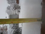
* SNOW ACCUMULATIONS...6 TO 8 INCHES.
* WINDS AND VISIBILITY...EAST TO NORTHEAST WINDS FROM 10 TO 20 MPH
AND A FEW HIGHER GUSTS. SOME MINOR BLOWING AND DRIFTING SNOW MAY
OCCUR. VISIBILITY MAY BE REDUCED TO LESS THAN A HALF MILE.
* IMPACTS...TRAVEL CONDITIONS ARE EXPECTED TO RAPIDLY DETERIORATE
SATURDAY EVENING...WITH SNOW AND ICE COVERED ROADS PERSISTING
INTO MONDAY MORNING IN MOST AREAS.


")